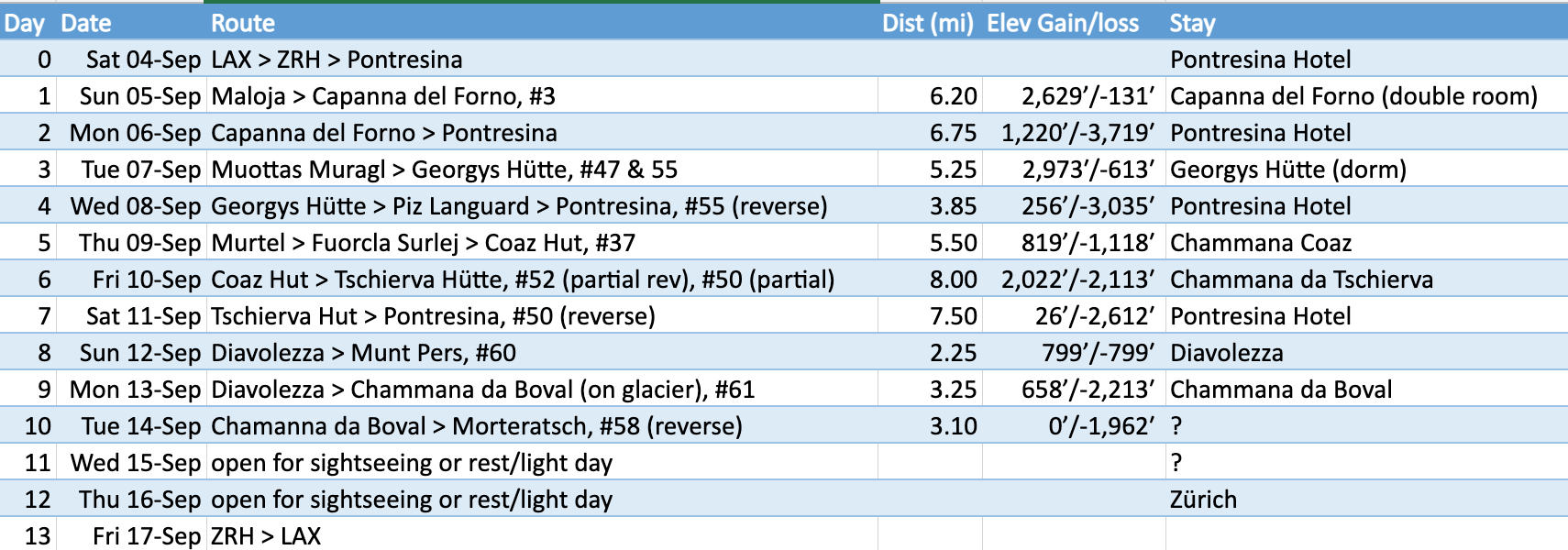
I planned 10 days of hiking among 4,000 meter high peaks, crossing glaciers, sleeping in alpine huts and picturesque villages in the Bernina Alps in the Graubünden canton of southeast Switzerland, along the border with Italy. 2 additional days were open for rest days, sight-seeing, or side trips. But two days before we were to board our flights, the EU removed the US from the list of “safe”countries (re covid), and the US raised the travel advisory for Switzerland to “4 – do not travel” due to covid concerns. So we decided to cancel given uncertainties about impacts from these changes.
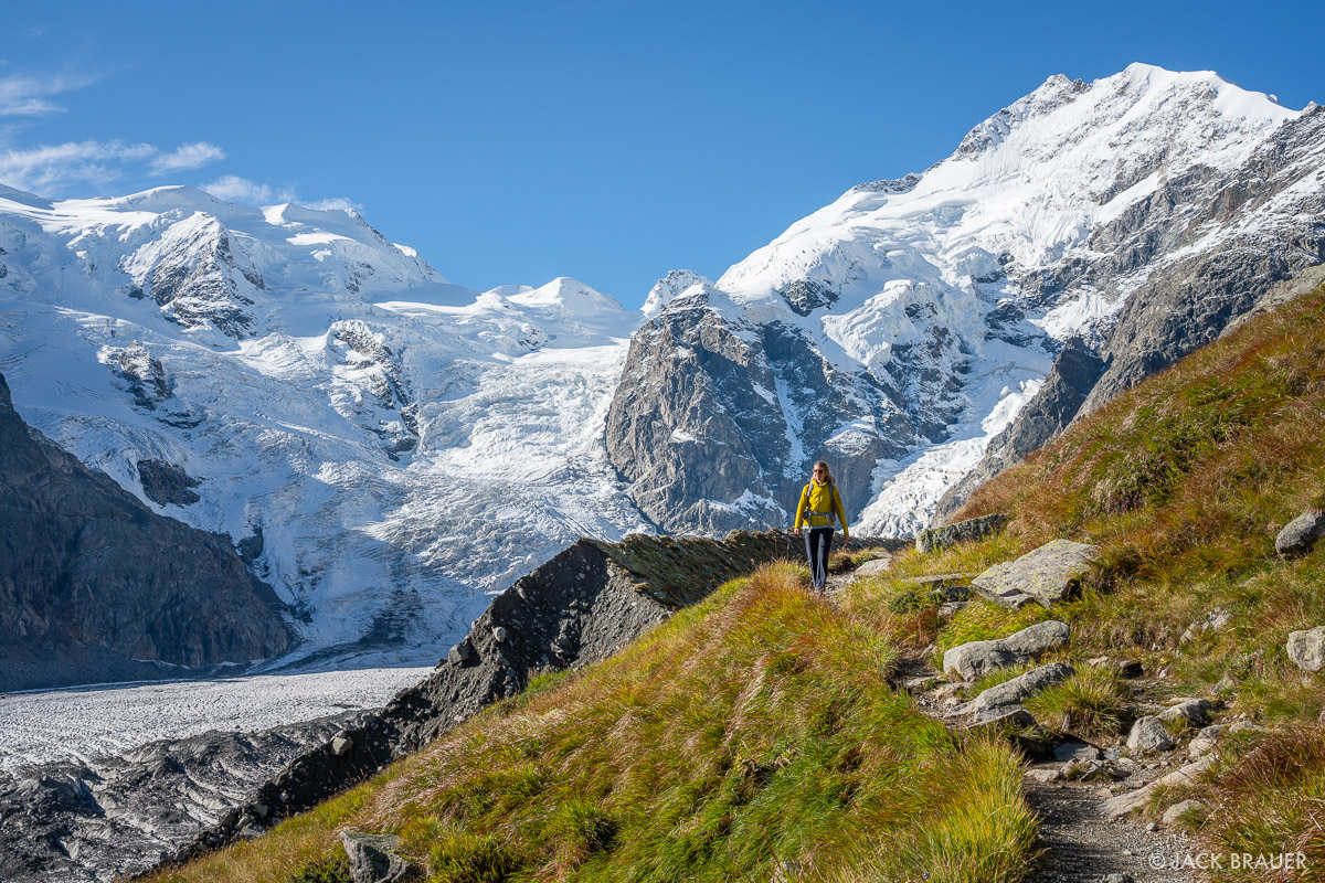
used without permission from Mountain Photography by Jack Brauer
See the Walking in the Engadine – Switzerland guidebook for detailed descriptions of the routes numbered below. I strung some of these together to make multi-day hikes with overnight stays in Alpine huts. There are few passes over the ridges that separate the valleys, so there is not much opportunity for extended hut-to-hut hikes; so will have to “rough it” in rustic hotels and enjoy the local cuisine in the village of Pontresina on a few nights.
Itinerary
Overnight Huts
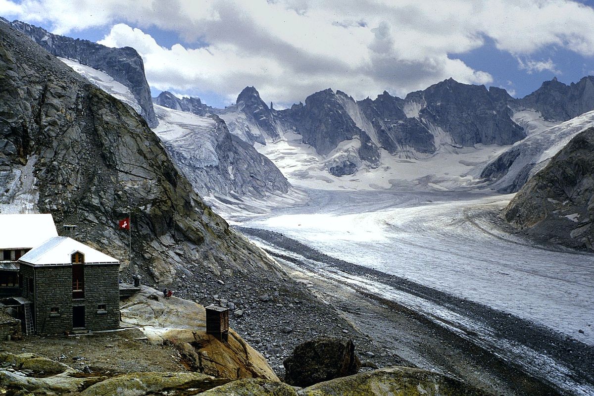
- Capanna del Forno – overlooks glacier and peaks above
- Georgys Hütte – located just below the summit of the Piz Languard with an eye-level view of the Bernina and routes covered in subsequent days
- Chamanna Coaz – great views of big glaciers and peaks
- Chamanna da Tschierva – more glacier views
- Chamanna da Boval – view of glaciers crossed enroute to this hut

used without permission from Ning Ning’s blog
Routes
Overview map of all planned routes overlaid on Swiss cartography – zoom in to inspect individual routes.
Other Maps
- SwissTopo – routes overlaid (in magenta color) on the official Swiss Cartography in full-screen – zoom in for richer detail (turn off the Hiking Trails option which will obscure these routes). Click on a route for description and elevation profile.
not sure if this map will expire in the future - KML file – download and open to visualize all hiking routes in Google Earth. Click on a route for description; right-click for elevation profile.
Capanna del Forno
An out-and-back hike from near Maloja to the Forno hut above the Forno Glacier.
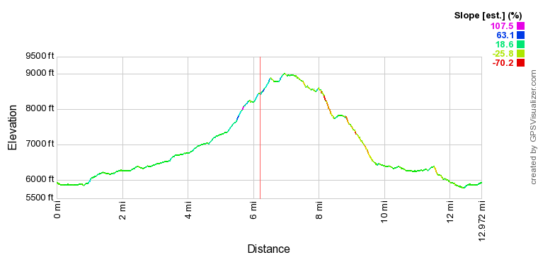
Maloja – Capanna del Forno
distance: 6.25 mi
min/max elev.: 5,858’/8,454′
elev. gain/loss: 2,629’/-131′
Capanna del Forno – Maloja
distance: 6.75 mi
min/max elev.: 5,780’/9,004′
elev. gain/loss: 1,220’/-3,719′
Total
distance: 13 mi
min/max elev.: 5,780’/9,004′
elev. gain/loss: 3,849’/-3,849′
Capanna da l’Albigna – Capanna del Forno
(not doing this one) An alternate route to the Forno hut which adds an overnight stay at the Albigna hut. The route between the huts is a blue-signed “alpine route” (T4+) for experienced mountaineers.
All but a couple hundred feet of the 3,600+ft climb to the top of the dam can be eliminated by riding the cable car from Pranzaira, but leaves only a 1-mile stroll to the Albigna hut.

Vicosoprano – Albigna
distance: 3.5 mi
min/max elev.: 3,640’/7,110′
elev. gain/loss: 3,465′/-6′
Capanna da l’Abigna – Capanna del Forno
distance: 4.35 mi
min/max elev.: 7,283’/9,736′
elev. gain/loss: 3,235’/-2,468′
Total
distance: 15.5 mi
min/max elev.: 3,640’/9,736′
elev. gain/loss: 8,359’/-6,116′
Albigna – Capanna da l’Abigna
distance: 1 mi
min/max elev.: 7,029’/7,655′
elev. gain/loss: 608’/-52′
Capanna del Forno – Maloja
distance: 6.7 mi
min/max elev.: 5,780’/9,004′
elev. gain/loss: 1,050’/-3,591′
Piz Languard
A ride up the funicular to Muottas Muragl and then a hike over and up to Georgys hut, with a stop for lunch at the Segantini hut for lunch. The second day is a descent to the chairlift at Alp Languard for a ride back down to Pontresina.

Muottas Muragl – Georgys Hütte
distance: 5.25 mi
min/max elev.: 7,694’/10,410′
elev. gain/loss: 2,973′/-613′
Georgy’s Hütte – Piz Languard – Alp Languard
distance: 3.85 mi
min/max elev.: 7,631’/10,666′
elev. gain/loss: 256’/-3,035′
Total
distance: 13 mi
min/max elev.: 5,780’/9,004′
elev. gain/loss: 3,849’/-3,849′
Chamanna Coaz – Chamanna da Tschierva
A cable-car ride up to the middle-station on Corvatsch, followed by a hike over to the Coaz hut for an overnight stay with big glacier views. The following day is a hike down into the valley and up the other side to the Tschierva hut. The third day is a walk down the valley back to Pontresina.
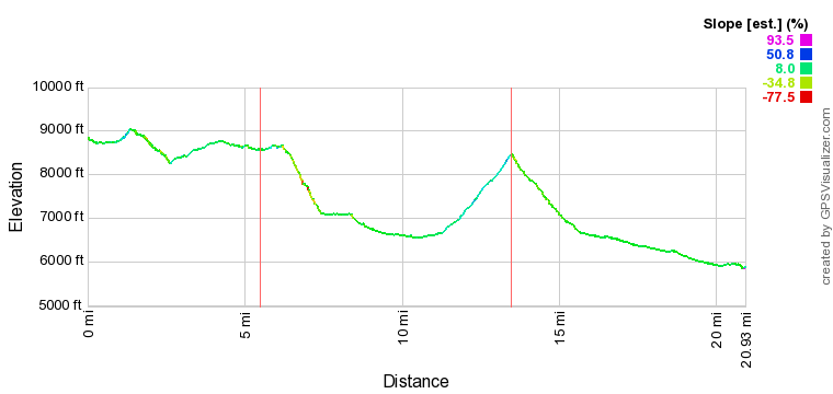
Murtel – Chamanna Coaz
distance: 5.5 mi
min/max elev.: 8,259’/9,037′
elev. gain/loss: 819’/-1,118′
Chamanna da Tschierva – Pontresina
distance: 7.5 mi
min/max elev.: 5,858’/8,471′
elev. gain/loss: 26’/-2,612′
Chamanna Coaz – Chamanna da Tschierva
distance: 8 mi
min/max elev.: 6,559’/8,672′
elev. gain/loss: 2,022’/-2,113′
Total
distance: 21 mi
min/max elev.: 5,858’/9,037′
elev. gain/loss: 2,866’/-5,843′
Diavolezza – Chamanna da Boval
A cable-car ride up to Diavolezza for a short hike to the summit of 3,200m Munt Pers and an overnight stay at Diavolezza. Next day is a guided descent across two glaciers to the Boval hut. Day 3 is a walk down the valley to Morteratsch, to return to Pontresina or head off in a new direction for the two “free” days.

Diavolezza – Munt Pers
distance: 2.25 mi
min/max elev.: 9,730’/10,497′
elev. gain/loss: 799’/-799′
Chamanna da Boval – Morteratsch
distance: 3.1 mi
min/max elev.: 6,221’/8,187′
elev. gain/loss: 0’/-1,962′
Diavolezza – Chamanna da Boval
distance: 3.2 mi
min/max elev.: 7,818’/9,742′
elev. gain/loss: 658’/-2,213′
Total
distance: 8.5 mi
min/max elev.: 6,221’/1,0497′
elev. gain/loss: 1,457’/-4,974′
used without permission from Hans Jürgens Bergfotoseiten